
Introduction
![]() High Raise (Langdale) is the highest point on the line of fells that form the central watershed of the Lake District and form the boundary between the generally smooth sloped fells of the east and the rocky fells of the west. High Raise is a good viewpoint for this change, with good views east towards the Helvellyn range and west and south towards the Scafell range and surrounding peaks. Like most of these central fells High Raise is a fairly smooth fell itself, with a wide grassy summit plateau. There are two rocky areas nearby - High White Stones and Low White Stones, but the overall scene around the top is not that dramatic.
High Raise (Langdale) is the highest point on the line of fells that form the central watershed of the Lake District and form the boundary between the generally smooth sloped fells of the east and the rocky fells of the west. High Raise is a good viewpoint for this change, with good views east towards the Helvellyn range and west and south towards the Scafell range and surrounding peaks. Like most of these central fells High Raise is a fairly smooth fell itself, with a wide grassy summit plateau. There are two rocky areas nearby - High White Stones and Low White Stones, but the overall scene around the top is not that dramatic.
The top of High Raise isn't terribly interesting, but its eastern flanks include some of the most attractive areas of the entire district. Here a series of ridges run east towards Grasmere, studded with attractive tarns (Codale Tarn and Easedale Tarn being the best known), and leading to some splendid fells (including Helm Crag and Silver How). These areas might fall outside the borders of High Raise, but they do set the scene.
![]() High Raise doesn't actually cover too much ground. In the south it is bordered by Thunacar Knott, and to the north by Ullscarf. To the south-east Sergeant Man is sometimes treated as a separate summit, although its only really an rocky outcropping on the edge of High Raise. Below Sergeant Man is a long ridge that forms the northern border of Great Langdale, ending at Dow Bank, but this is best seen as a series of separate fells in its own right. To the north-west the fell runs into another ridge, between Greenup Gill and Langstrath. This ends at Sergeant's Crag, which really counts as a fell itself. The biggest slopes are to the west, where long steep slopes run down to Langstrath, getting steeper in their lower reaches.
High Raise doesn't actually cover too much ground. In the south it is bordered by Thunacar Knott, and to the north by Ullscarf. To the south-east Sergeant Man is sometimes treated as a separate summit, although its only really an rocky outcropping on the edge of High Raise. Below Sergeant Man is a long ridge that forms the northern border of Great Langdale, ending at Dow Bank, but this is best seen as a series of separate fells in its own right. To the north-west the fell runs into another ridge, between Greenup Gill and Langstrath. This ends at Sergeant's Crag, which really counts as a fell itself. The biggest slopes are to the west, where long steep slopes run down to Langstrath, getting steeper in their lower reaches.
The summit is a good viewpoint, especially for the Scafell range. On a busy day in the Langdales it can also be a quiet refuge, although the crowds are normally visible on Sergeant Man and on Pavey Ark.
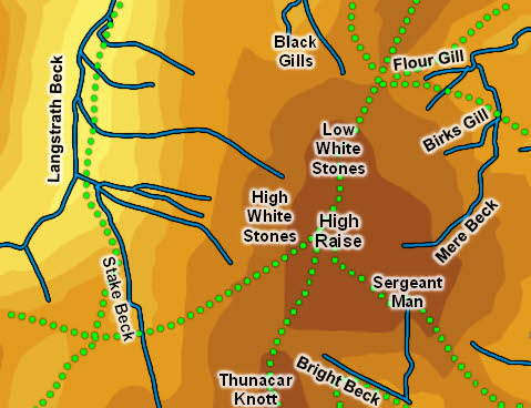
Statistics
Grid Reference of Summit: NY 280 095
Height: 762m
Map
Routes of Ascent
From Borrowdale the best route is to follow the path along the northern side of Stonethwaite Beck. When this path turns south and crosses Greenup Gill leave it and follow Greenup Gill as it runs south-east to Greenup Edge, then turn right to reach the summit over Low White Stones.
From Langdale head up to Stickle Tarn. Head right around the lake until you find a path that heads off to the east/ north east. Follow this path as it follows the ridge up to Sergeant Man, then head north-west across the plateau to High Raise.
From Grasmere there are two main routes. One follows Far Easedale to its head, then splits - either take the path west to Greenup Edge then turn left, or head south on the path that runs east of Mere Beck to reach Codale Head, then turn right. The second route is to head to Easedale Tarn, then take the path that leads on beyond the tarn and up a gap in the tarns to reach the ridge east of Sergeant Man.
The summit can also be reached easily from the Langdale Pikes by heading along the path that runs past Thunacar Knott and then curves around to Sergeant Man - this path splits as it starts to climb - at this point keep heading north, ignoring the path that runs north-east towards the Man.
Walks
Our walk in the Langdale Pikes visits High Raise after exploring the Pikes themselves.
The Summit
The summit is a largely grassy area, with a trig point on top of the gently rising summit dome.
Streams and Tarns
A nameless beck runs west from the col between High Raise and Thunacar Knotts. This then joins Stake Beck, which flows north-west into Langstrath Beck., which then flows north forming the western boundary of the fell.
On the other side of the col Bright Beck flows east then south into Stickle Tarn, forming part of the southern boundary. Any of the nameless becks that run south from the ridge below Sergeant Man could serve as the south-eastern boundary.
In the north Greenup Gull rises close to Greenup Edge and flows north-west into Langstrath Beck. Nameless becks form general boundaries between the bulk of High Raise and Sergeant's Crag.
A convenient eastern boundary is formed by Mere Beck. which rises just north of Codale Head and then flows north past the fell. Flour Gill rises on the eastern side of Greenup Edge and flows east to join Mere Back.
High Raise has no named tarns (within the bounds I've chosen), but there are plenty of small pools around Sergeant Man.
Other Features
-