
 This walk takes us to the summit of Helvellyn, one of the most famous of all Lake District peaks, without approaching either of the infamous ridges. This route also has the advantage that it takes us to six summits (including Little Man) and visits Grisedale Tarn.
This is a long, strenuous walk, which really needs a full day to appreciate properly.
Ascent: 3,500ft/ 1070m
Length: 12.5 miles/ 20km
Map: Explorer 005 English Lakes North East
Last Walked: 8 August 2005
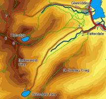
We start from Patterdale for reasons of parking - there is a reasonable all-day car park opposite the hotel in Patterdale which is much cheaper than any parking I found in Glenridding.
![]() At the edge of the valley bottom our path passes through a wall. Turn left and follow the path that runs alongside this wall, heading up Grisedale. Don't take the more obvious path that begins to climb up away from the valley bottom - this is
At the edge of the valley bottom our path passes through a wall. Turn left and follow the path that runs alongside this wall, heading up Grisedale. Don't take the more obvious path that begins to climb up away from the valley bottom - this is ![]() the path to Striding Edge.
the path to Striding Edge.
We now stay on this path all the way to Grisedale Tarn. Navigation is simple - keep on heading up the valley, staying on the right hand side of the beck all the way up.
![]() At the top of Grisedale we reach Grisedale Tarn. Our path passes to the right of the tarn. Soon after we draw level with the tarn, the path splits. The left hand branch continues close to the tarn, while the right hand (clearer) path zigzags up the slope to the right. Follow this path as it climbs up onto the ridge that leads to Helvellyn.
At the top of Grisedale we reach Grisedale Tarn. Our path passes to the right of the tarn. Soon after we draw level with the tarn, the path splits. The left hand branch continues close to the tarn, while the right hand (clearer) path zigzags up the slope to the right. Follow this path as it climbs up onto the ridge that leads to Helvellyn.
The path is now clear and obvious all the way to the summit of Helvellyn. However the main path passes to the left of the summits of Dollywaggon Pike, High Crag and Nethermost Pike, each of which is worth "bagging" on the way past. In mist or fog stick to the main path, which is at least safely distant from the lines of crags to the east.
![]()
![]()
The top of Helvellyn is almost always busy, but even on a clear summer day I was able to find relative solitude by moving slightly away from the cairn and the crowds coming up the edges.
![]()
![]()
![]()
To continue on follow the main ridge as it heads north west to Helvellyn Lower Man
![]() From the summit of Whiteside Bank we continue along the ridge towards Raise, with Keppel Cover to our right. Just after leaving the summit, the path splits in two. Take the right hand branch that curves around the top of the cove.
From the summit of Whiteside Bank we continue along the ridge towards Raise, with Keppel Cover to our right. Just after leaving the summit, the path splits in two. Take the right hand branch that curves around the top of the cove.
After about half a mile the path turns right and zigzags down into the valley of Glenridding. At the bottom of the zigzags the path reaches a track that runs down the valley bottom. Turn left and head down the valley. We follow this track all the way into the village of Glenridding. Take care where the track passes through some abandoned mine works (close to the Youth Hostel).