
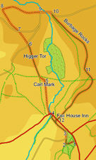
 This walk is dominated by the millstone grit edges that line the Derwent Valley. We visit the hill fort of Carl Wark, the dominating heights of Higger Tor and the southern end of Stanage Edge, before returning along the top of Burbage Rocks.
Ascent: 970ft/ 300m
Length: 5.5 miles/ 8.8km
Map: Explorer 001 Dark Peak
Last Walked: 2 August 2007
We start from the National Trust car park for Longshaw Lodge, just off the A 6187 close to Fox House Inn..
![]() At the foot of the crags we have two choices of route. It is possible to bypass the Carl Wark to the left, following the clear path that runs around the western flank of this feature, but a much more interesting route is to scramble up the southern slope of Carl Wark to reach its rocky summit.
At the foot of the crags we have two choices of route. It is possible to bypass the Carl Wark to the left, following the clear path that runs around the western flank of this feature, but a much more interesting route is to scramble up the southern slope of Carl Wark to reach its rocky summit.
From here our route on is obvious. Higger Tor now dominates the northern skyline, with a clear path running straight from the northern tip of Carl Wark to the base of the tor. Follow this path, then climb up the crags to the southern tip of Higger Tor.
From the top of crags it becomes obvious that the crags only run around two of the three sides of the tor - the southern and eastern, while to the north only a gentle dip separates Higger Tor from the higher moors beyond. Our next target, the southern end of Stanage Edge, is now visible on the northern skyline.
Follow the path that runs north close to the eastern edge of Higger Tor. At the northern edge of the tor, the path dips down into the gap between the tor and the rest of the moors, and then splits in two. Take the left hand branch, which heads along the highest part of this minor ridge, heading towards the distant crags. After a short distance this path reaches a minor road opposite a small roadside car park. Cross this road, and continue in the same direction along a footpath that leaves the road just to the right of the car park.
![]() This path brings us to a point just to the left of the southern end of the crags of Stanage Edge. The path itself continues on to the left for a short distance after it reaches the foot of the crags, before climbing up to the top of the crags on a couple of well-worn routes. Just before reaching this point, it is worth taking a diversion to
This path brings us to a point just to the left of the southern end of the crags of Stanage Edge. The path itself continues on to the left for a short distance after it reaches the foot of the crags, before climbing up to the top of the crags on a couple of well-worn routes. Just before reaching this point, it is worth taking a diversion to ![]() an old quarry, where it becomes obvious why the local stone is called millstone grit, for a number of abandoned heavy millstones remain in the quarry.
an old quarry, where it becomes obvious why the local stone is called millstone grit, for a number of abandoned heavy millstones remain in the quarry.
At the point where we reach the top of the edge, two paths head east - one running around the top of the edge and one that runs a little further to the left, cutting off a corner. Both paths lead to the ![]() correct place, but the path that runs around the top of the edge, visiting a trig point on the way, offers the best views. Follow this path around the southern edge of the Edge, until it rejoins the alternative route. From here the route onwards is very obvious - a very clear path drops down the eastern flank of the edge, and heads almost due east through the heather.
correct place, but the path that runs around the top of the edge, visiting a trig point on the way, offers the best views. Follow this path around the southern edge of the Edge, until it rejoins the alternative route. From here the route onwards is very obvious - a very clear path drops down the eastern flank of the edge, and heads almost due east through the heather.
![]() We follow this road past a car park, and then across two bridges over small streams. At the second bridge the road turns to the right, and runs towards another small car park. At the near end of this car park, turn right onto a footpath that leads into the valley of Burbage Brook, with Higger Tor to the right and Burbage Rocks to the left. Our aim is to follow the path that runs along the top of Burbage Rocks all the way back to the main road we crossed back at step four.
We follow this road past a car park, and then across two bridges over small streams. At the second bridge the road turns to the right, and runs towards another small car park. At the near end of this car park, turn right onto a footpath that leads into the valley of Burbage Brook, with Higger Tor to the right and Burbage Rocks to the left. Our aim is to follow the path that runs along the top of Burbage Rocks all the way back to the main road we crossed back at step four.
The main path here follows the line of the brook down the valley, so the moment we leave the road, look for a smaller path that leaves to the left, climbing up towards the edge of the rocks. Here we have a choice of two paths - a large path that runs a little way from the edge, or a smaller path that runs along the rocks. This smaller path offers better views, but the two paths soon merge, so either route is fine.
![]() There is only one gap in this line of crags. Here our path drops down to cross a small stream. On the far side of the stream it then turns slightly to the left and climbs up towards the next line of crags. Just before we reach the next set of crags we reach a crossroads in the path - head straight across this. Soon afterwards, the path reaches the start of the next set of crags - turn right, and follow this path as it runs south west along the top of crags, before eventually dropping down to the main road.
There is only one gap in this line of crags. Here our path drops down to cross a small stream. On the far side of the stream it then turns slightly to the left and climbs up towards the next line of crags. Just before we reach the next set of crags we reach a crossroads in the path - head straight across this. Soon afterwards, the path reaches the start of the next set of crags - turn right, and follow this path as it runs south west along the top of crags, before eventually dropping down to the main road.
Bookmark this page:
![]() Delicious
Delicious
![]() Facebook
Facebook
![]() StumbleUpon
StumbleUpon