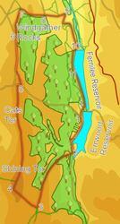
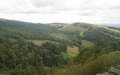
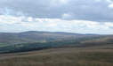
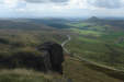
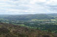
 This walk in the Goyt Valley takes in Errwood and Fernilee Reservoirs, as well as climbing to the summit of Shining Tor, the highest point in this part of the Peak District. This is a fine ridge walk, with sweeping views in every direction, but particularly across the plains to the west and north towards Kinder.
Ascent: 1,500ft/ 460m
Length: 8.8 miles/ 14km
Map: Explorer 024 White Peak Area
Last Walked: 7 August 2007
We start from the car park at the north western corner of Errwood Reservoir, at the junction between the lake side road and "The Street", the road that heads west from the lake.
1: SK 013 756
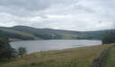
From the car park turn right onto the lake side road and follow it south, with the lake to the left and the hillside to the right.
2: SK 012 747
We follow this road almost to the southern tip of the lake, crossing over a bridge and passing a second car park. Just beyond that second car park, look for a signposted footpath that leaves the road to the right, climbing up into the trees. Turn right and follow this path.
 The path climbs up through a narrow band of trees, and then emerges into a narrow strip of open ground between two small woods. We follow this path for the next mile and a third, as it climbs up the ridge between Shooter's Clough to the right and Stake Clough to the left. As we climb, Shining Tor comes into view to the right. Ignore the paths that leave the ridge line.
3: SK 000 731
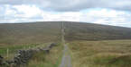
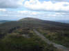
We continue on this path until we reach the top of the ridge. At this point cross over the wall to the right, and head along the major path that dips down for a short distance, before climbing directly towards the summit of Shining Tor, keeping the stone wall to our left (see picture).
4: SJ 994 737
At the summit of Shining Tor the wall and the path both turn through ninety degrees to the right, with convenient benches in the corner. Turn right and follow this path as it runs north along the ridge line from Shining Tor towards Cats Tor and beyond.
5: SJ 995 767
After just under two miles this path reaches the road known as "The Street" where it crosses over the ridge line. Follow the path as it drops down to the road, and then climb up the bank on the opposite side of the lane, to reach a path that runs parallel to the road. Turn right onto this path, and follow it for around 200 feet, until we reach a footpath signposted to the left. Turn left onto this path and follow it across north through the heather. After a short distance the path reaches the south eastern corner of a field, crosses diagonally across that field and reached another side road. From here we need to follow the line of the road to the north, either on the road itself, or along a path that runs just inside the field to the right. After wet weather the road route is preferable, as the field path can get rather overgrown in pldaces.
6: SJ 995 780
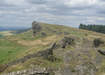 Both routes lead towards Windgather Rocks, a popular climbing area. The field path runs straight up to the top of the rocks. If the road has been used, then follow it until you reach some road-side parking, just before the road curves away to the left. There look for some steps that climb over the wall to the right, rejoining the field-side path. Follow this path as it follows the line of the ridge up to the rocks.
From the rocks continue north into the next field, and then north through that field, with Taxal Edge to the left, and some woods to the right, heading towards a farm.
7: SJ 996 788
A rough lane passes just in front of that farm, only partly walled in to the south. Turn right onto this lane, and follow it as it leaves the north eastern corner of this field. This brings us to the edge of a much larger field. Directly in front of us is a single tree standing at the western end of a stone wall. We need to pass to the left of that tree, and then follow the stone wall as it runs east, along the southern edge of this field. Ignore the track that follows a grove in the hillside a little further to the left.
We follow this path all the way to the south eastern corner of the field. Here the path crosses into another area of heather, climbs up to another ridge line, and then drops down the eastern flank of the ridge, back into the Goyt Valley. Follow this path down the hillside until it reaches a minor road.
8: SK 003 786
Cross over this road, and follow a farm track as it runs down the hill towards Overton Hall Farm. As we follow this track, the valley of Mill Clough begins to open up to the right.
9: SK 008 786
Continue on past the farm for another 600 feet. At this point the track turns sharply to the right, doubles back on itself, and heads down into the valley. Follow this track as it heads south west down the hill, eventually reaching the valley bottom, where the track turns sharply to the left and begins to climb gently out back of the valley. We follow this track to the east for around 700 feet towards a set of buildings, where it turns to the right to heads south. We stay on this track until it reaches the western end of Fernilee Dam.
10: SK 012 776
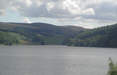
At the dam turn right onto a track lane that runs south west, with the lake to the left. After a short distance turn onto a path that heads into the trees to the left, running along the western shore of the lake.
11: SK 011 770
We follow this first path for about a third of a mile through the trees. At this point we turn left onto a smaller path that runs closer to the water, and follow this path to the southern end of the lake.
12: SK 014 759
At the southern end of the lake we need to climb back up to the level of the car park. There are two alternatives. Just before we reach the end of the lake, the path splits in two - the right hand branch climbs up through the trees to reach the road across the dam, while the left hand branch continues along to the foot of the dam, and then climbs up the the western edge of the dam, joining the road at the same point. Follow the line of this road south west back to our starting point.
Bookmark this page:
 Delicious
 Facebook
 StumbleUpon
