
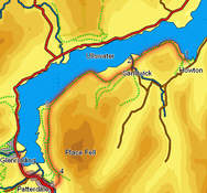
 This is one of the classic Lake District Walks, using the Ullswater ferry to reach Howton, before returning to Glenridding along the lake shore.
One of the best features of this walk is the way the views change along the route. At first Ullwater and the gentle fells on its northern shores dominate, but as we head west, the Hellvelyn range takes over, and the walk finishes in the middle of some of the most impressive mountain scenery in the Lakes.
Ascent: 1,200ft/ 360m
Length: 6.4 miles/ 10km
Map: Explorer 05 English Lakes North East.
This walk starts at Glenridding, on the south western shore of Ullswater and uses the Ullswater Steamer to reach Howton. Visit their web site to check that the ferry is running before setting off for this walk (during 2008 the ferry will be running on every day apart from Christmas Eve and Christmas Day, but with a reduced timetable during the winter).
At Howton the ferry docks against a pier built at the end of a small spur of land that juts out into the lake. Follow the path that leads inland along this spur. Just as the spur reaches the main shore, the path splits in two. Take the right hand branch, and follow it along the shoreline.
After crossing two fields, this path joins a small road. Follow this road along the lake shore for a short distance, until you reach a path leaving to the left. Take this path, which cuts a corner across this field, and then passes through a narrow band of trees, before joining another path at a t-junction.
Turn right onto this path, and follow it as it curves around the northern slopes of Hallin Fell. The first part of this path runs between fields to the right and the open fell to the left, before emerging onto the open fellside to pass around the northern tip of the fell. Finally the path enters Hallinhag Wood, remaining in the woods almost all the way to the second break in the mountains, at Sandwick.
Remain on the lake shore path all the way through the woods, ignoring any side paths that head off up the fell side The path emerges from the western tip of the woods at Sandwick Bay. A very clear path then leads across a series of fields to Sandwick Beck. At the beck the path turns left, follows the line of the beck, before reaching a bridge across the beck. Cross over this bridge.
![]() On the far side of the beck the path reaches the road at Sandwick. Turn left onto this road and follow it south for a very short distance. Immediately to the south of the last of the buildings, turn right onto a footpath that climbs gently south west out of this valley. After a short distance this footpath merges with a larger track, and continues on to the south west, with the open fell side to the left and fields to the right.
On the far side of the beck the path reaches the road at Sandwick. Turn left onto this road and follow it south for a very short distance. Immediately to the south of the last of the buildings, turn right onto a footpath that climbs gently south west out of this valley. After a short distance this footpath merges with a larger track, and continues on to the south west, with the open fell side to the left and fields to the right.
![]() Follow this track all the way around the fields to the right. By the time it reaches the western tip of the fields the path is heading north west towards the lake shore. Follow it as it runs around the crags at the northern tip of Birk Fell. Just past those crags, the path enters another wooded area. Follow this obvious path all the way through these trees - sometimes it runs quite close to the water, but it does rise some way into the trees, and is sometimes 100ft higher than the water.
Follow this track all the way around the fields to the right. By the time it reaches the western tip of the fields the path is heading north west towards the lake shore. Follow it as it runs around the crags at the northern tip of Birk Fell. Just past those crags, the path enters another wooded area. Follow this obvious path all the way through these trees - sometimes it runs quite close to the water, but it does rise some way into the trees, and is sometimes 100ft higher than the water.
![]() At the western edge of the trees the path splits in two. The right hand branch follows the lake shore and runs to the north and west of Silver Crag, while the left hand branch climbs up and crosses the pass between Silver Crag and Birk Fell. Take this left hand branch - the top of the pass offers superb views towards Patterdale.
At the western edge of the trees the path splits in two. The right hand branch follows the lake shore and runs to the north and west of Silver Crag, while the left hand branch climbs up and crosses the pass between Silver Crag and Birk Fell. Take this left hand branch - the top of the pass offers superb views towards Patterdale.
A series of paths run parallel across the western slopes of Birk Fell. Our objective is to reach one of the bridges across the river that blocks our route to Patterdale - there are suitable bridges at Side Farm or at Rooking.
Our route uses the bridge at Side Farm. Follow the high level path for about a third of a mile from the highest point on the pass between Silver Crag and Birk Fell. At that point the path draws level with a single isolated field, with a clump of trees at its northern (near) end. Just as the high level path draws level with the trees, a side path splits away to the right, heading towards the southern tip of that field. Take this path, and follow it down the fell side until it joins a farm lane. Turn left onto this lane, and follow it south, towards the southern end of Ullswater.
Follow this track for about half a mile, with fields to the right and the open fell side to the left. Soon after passing through a small clump of trees, the track reaches Side Farm, passing to the left of the buildings. Turn right into the farmyard, and follow the track than runs south west across the valley bottom, reaching the main road at Patterdale.
Turn right and follow the main road back into Glenridding, taking advantage of the roadside path for most of the way, and using the permissive paths that run parallel to the road between Grisedale Bridge and Glenridding itself.