
 An interesting walk around one of the less well known Pennine Reservoirs. Even in the middle of summer, we saw nobody else during the entire walk. The first half of the walk is very gentle, along a well built and maintained path through the trees. The second half follows a real woodland path, and includes one minor scramble. There are several picnic areas along the path on the northern side of the reservoir.
Ascent: 220 feet/ 65 metres
Length: 2.7 miles/ 5 km
Map: OS Explorer Map 31 North Pennines: Teesdale and Weardale
Last Walked: 26 August 2006
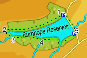
Parking is available at both ends of the dam, although the car park at the southern end was out of use on my last visit (August 2006) while building work was going on. To get to Burnhope Reservoir, follow the A689 west up Weardale. Take the second left hand turn in Ireshopeburn (NY 866 386). After a mile, take a right turn down a gated lane (please close the gate behind you). Alternately, continue along the A689 to Cowshill (NY 855 406). Turn left into the village, and then almost immediately left again (click on the walk map to go to a map of the wider area). You can drive across the dam.
The path continues on through the trees, still marked by the blue paint, although this eventually starts to run out. If in any doubt, keep to the path nearest to the lake - this path never climbs up too far away from the water. Half way back to the dam the path has to swing to the right to get around an inlet in the lake, where Whin Sike reaches the reservoir. On the far side of the sike, cross a short patch of open ground between the forest and the lake, re-entering the trees through a gap in a stone wall. Soon after this, the path joins a track, which runs alongside the lake.