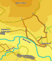
 This walk falls into two very distinct parts - in the first part we follow the River Tees just to the east of Middleton-in-Teesdale, while in the second half we climb up onto the moors, cutting across the lower slopes of Monk's Moor.
Ascent: 650ft
Length: 4.5 miles
Map: North Pennines
Last Walked: April 2011
We start at a lay by on B 6282 Middleton to Eagleston Road, where the road runs close to the top of the escapement above the River Tees.
1: NY 977 247
Head east along the road, with the valley of the River Tees on the right.
2: NY 982 245
Follow the road as it runs along the escarpment then drops down towards a road junction. Just before reaching this junction turn right onto a track that heads down the slope. Follow this track past Egglesburn Farm. Soon after passing the farm the track turns left - at this point leave it and follow a footpath that runs along the base of the escarpment, heading towards the River Tees. Follow the path as it runs alongside the River Tees, on an area of flat ground between the river and the slopes.
3: NY 969 250
We follow this path as it runs through two fields. At the end of the second field the flat area disappears. At this point look for a path that climbs diagonally up the slope (here named Sun Bank). Follow this path as it climbs up and across the hill, heading for a stone wall on the skyline. Cross this wall then follow the path straight across the next field, heading towards some farm buildings. Follow the signposted footpath until it reaches the main road.
4: NY 968 255
Turn right onto the road and then almost immediately turn left onto a side road that climbs up towards the moors. The lower stretch runs between improved fields, the upper stretch had more open moorland on the right.
5: NY 966 262
Follow this road until it ends at a T-junction. Turn right onto the next road and follow it as it runs alongside the moorland.
6: NY 974 266
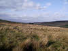
We follow this road until we reach a point where a stone wall crosses the open moorland to the right. Turn right onto a footpath that runs alongside this wall. This brings us to the north-east corner of the field, where a gate leads into a larger area of moor. Follow a footpath that cuts diagonally and to the right across this moorland.
7: NY 982 256
This path eventually brings us to a wall at the southern edge of the moorland. Head through a gate in the wall that leads onto a rough track. Follow this track south and then east, until we reach the top end of a minor road.
8: NY 983 253
Turn right onto this road and follow it past Standing Stones Farm. Continue on past the farm until you reach a signposted footpath heading off to the right. Turn onto this footpath and follow it through the next two fields.
9: NY 979 250
In the third field turn onto a path that cuts diagonally across the field to the left, with some farm buildings on the right. Just past the farm buildings this path reaches a track. Turn left onto this track and follow it back to the road, which we reach close to the parking area.
