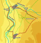
 This shorter walk starts with a pleasant walk along the banks of the Ribble, visiting Stainforth Bridge, one of the most attractive in the Dales. It then climbs up to Catrigg Force, before making a high level return to Langcliffe. This final part of the walk gives us some sweeping views back up the valley and towards Pen-y-Ghent and Fountains Fell.
Ascent: 920ft/
Length: 5.4 miles/
Map:
Map: Yorkshire Dales - Southern and Western Areas (OS Explorer Map Active) (OS Explorer Map Active)
Last Walked: 12 May 2008
We start from the free car park at the eastern edge of the village of Langcliffe, just off the B 6479 Ribblesdale road.
1 (SD 823 650)
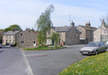
Starting from the car park at the eastern tip of Langcliffe, head into the village, and follow any of the roads through the village and onto the B 6479.
2 (SD 820 650)
Turn right and follow the main road north.
3 (SD 820 653)

After a short distance the road curves to the left and crosses over the Settle-to-Carlisle railway. Just past the bridge over the railway, a minor lane leaves to the left, heading downhill towards the Ribble. Turn left and follow this lane down to the river.
4 (SD 817 654)
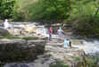
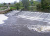 We reach the river just above a weir that provides water for a small reservoir. Cross the river on a small footbridge just below the weir, then turn right and follow the riverside path for the next mile and a half, all the way to Stainforth Force and Bridge.
 One of the more notable features of this stretch of the walk comes close to the end, when the path crosses a stream only feet after it emerges from its subterranean watercourse to plunge down into the Ribble, a reminder that we are firmly in limestone country.
5 (SD 817 672)
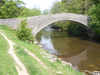
Follow the path onto the minor lane that crosses Stainforth Bridge, turn right, cross the bridge and follow this lane as it climbs all the way back up to the main road. Cross the road, then turn right and follow it to the village of Stainforth.
6 (SD 820 672)
A number of roads lead into Stainforth. Take the second of these, just to the north of Stainforth Beck and a car park.
7 (SD 821 674)
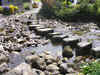
This road brings us to a T-junction. Take the left hand branch, then follow it as it curves around to the right. After a short distance we reach a point where stepping stones cross the beck that runs through the village. Cross these stepping stones to reach a triangle shaped village green. A rough track leaves this green from the far corner, climbing steeply up out of the village. Take this track.
8 (SD 831 670)
 We follow this track for two thirds of a mile, as it climbs up between fields, with the valley of Stainforth Beck to the left. Just before the track emerges into a larger field, a footpath
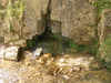
  leaves to the left, signposted for Catrigg Force. Follow this path down to the waterfall. A side path leads through the trees to the left, leading to the base of the waterfall.
After visiting the waterfall return to the lane and pass through the gate into the next field. Turn right and follow the track as it heads gently uphill towards the right hand end of the field.
9 (SD 832 667)
Pass into the next field, and then continue on along the track as it curves slightly to the left, following it all the way to a minor road.
10 (SD 839 664)
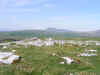
Turn right onto this minor road and follow it all the way back into Langcliffe. On its way the road passes through areas of limestone pavements and past the Winskill Stones Nature Reserve, and offers fine views north towards Pen-y-Ghent and Ribblesdale, before dropping back into the village right by the car park.
