
 This walk has the great advantage of being a quiet walk on Pen-y-Ghent, one of the busiest summits in the Yorkshire Dales. On just about every day of the year this mountain is full of people doing the Three Peaks or the Pennine Way, but our route avoids both of those routes for most of its length. On a sunny sunday we passed two other groups of walkers on the ascent, but dozens at the summit.
Ascent: 1,950ft/
Length: 11 miles/
Map:
Map: Yorkshire Dales - Southern and Western Areas (OS Explorer Map Active) (OS Explorer Map Active)
Last Walked: 11 May 2008
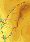
Start at the Pen-y-Ghent cafe, in the centre of Horton-in-Ribblesdale. Cross the road, and turn ![]() right. After a short distance a track leaves to the left, signposted for Pen-y-Ghent and the Pennine Way. This lane quickly climbs up out of the village onto the flanks of Pen-y-Ghent, heading east for a short distance before turning to the left.
right. After a short distance a track leaves to the left, signposted for Pen-y-Ghent and the Pennine Way. This lane quickly climbs up out of the village onto the flanks of Pen-y-Ghent, heading east for a short distance before turning to the left.
We follow this rocky track for just over a mile and a half as it heads north east, running almost parallel to the western face of Pen-y-Ghent. Towards the end of this part of the walk we pass a series of dramatic dry waterfalls in the valley to the right of the lane, ending at Tarn Bar. Just past the last of these the track turns sharply right, then curves around to the left before emerging from between its stone walls into an open field.
Here the Pennine Way turns right, heading directly for the front of Pen-y-Ghent, but we ignore this turn, and continue north east along the track, following the valley as it runs between low hills. This track brings us up to Hull Pot. This massive pot holl is dramatic, but unfenced, so be careful!
![]()
![]()
![]()
Just to the east of Hull Pot a stile crosses the wall on the right hand side of the valley. Cross this stile. On the far side a path follows the line of a minor side valley. Follow this path as it curves gently around to the left, passing the point where one of the rare upland streams in this area disappears underground.
We soon reach a crossroads in the path, where our route crosses the Three Peaks route. On a clear day Whernside can be seen along the left hand branch, which heads straigh as an arrow across the moor. Our route crosses this path and continues on to the north east, running to the left of a stone wall. We follow this wall for the next mile, and then continue along the same path past the end of the wall.
![]() The point we leave this path to climb up Plover Hill is marked by a rather unexpected signpost. Turn right at the sign, and follow the path as it climbs up the increasingly steep northern slope of Plover Hill. At the top of this steep climb we pass through a gap in a stone wall which brings us to the base of the line of cliffs that surround the summit plateau.
The point we leave this path to climb up Plover Hill is marked by a rather unexpected signpost. Turn right at the sign, and follow the path as it climbs up the increasingly steep northern slope of Plover Hill. At the top of this steep climb we pass through a gap in a stone wall which brings us to the base of the line of cliffs that surround the summit plateau.
![]() From a distance the path looks as if it dangles over the edge of massive cliffs, but in fact although our path does indeed go very close to the top of the cliffs, it does it at a point where the cliffs are only a few feet high (the first time I used the path was in such a heavy mist that we appeared to be climbing precariously over a huge drop, but on the last visit it was much less alamring). After passing the cliffs the path curves around to the right, before emerging onto the summit plateau of Plover Hill.
From a distance the path looks as if it dangles over the edge of massive cliffs, but in fact although our path does indeed go very close to the top of the cliffs, it does it at a point where the cliffs are only a few feet high (the first time I used the path was in such a heavy mist that we appeared to be climbing precariously over a huge drop, but on the last visit it was much less alamring). After passing the cliffs the path curves around to the right, before emerging onto the summit plateau of Plover Hill.
![]() We emerge onto the plateau by the side of a stone wall, which runs south across the hill. Our path heads a little to the right of this path, heading for a stile that crosses a wall running east to west across the summit. Cross this stile and then follow the path as it runs to the right of a stone wall which runs all the way to the summit of Pen-y-Ghent - after running south west for for just over half a mile, this path then turns left and heads straight for the summit.
We emerge onto the plateau by the side of a stone wall, which runs south across the hill. Our path heads a little to the right of this path, heading for a stile that crosses a wall running east to west across the summit. Cross this stile and then follow the path as it runs to the right of a stone wall which runs all the way to the summit of Pen-y-Ghent - after running south west for for just over half a mile, this path then turns left and heads straight for the summit.
![]()
![]()
![]() Just across the bridge we pass a pub. Follow the signposted footpath that crosses the pub car park, before cutting across two small fields to reach a minor road. A permissive footpath runs along side this footpath, so turn right and follow this footpath to its end. At this point the minor roads turns sharply to the left, while our path turns to the right, running along a narrow lane which passes under the Settle to Carlisle railway, then turns left, running close to the River Ribble before emerging into a large field.
Just across the bridge we pass a pub. Follow the signposted footpath that crosses the pub car park, before cutting across two small fields to reach a minor road. A permissive footpath runs along side this footpath, so turn right and follow this footpath to its end. At this point the minor roads turns sharply to the left, while our path turns to the right, running along a narrow lane which passes under the Settle to Carlisle railway, then turns left, running close to the River Ribble before emerging into a large field.
Head straight across this field. At the far side we reach the edge of the Ribble. Turn left and follow the river as it curves around to the right, passing a farm and its associated bridge on the way. After just under half a mile we reach a footbridge that crosses back to the eastern bank of the river.