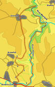
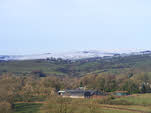
 This walk at the southern end of the Peak District takes us into quiet hills above the Manifold valley, before returning to Waterhouses along the very popular Manifold Way.
Ascent: 1,200ft
Length: 9.5 miles
Map: Explorer 24 White Peak
Last Walked: 31 December 2010
We start from the National Park car park just off the main road - take the first left if coming from the east, first right if coming from the west, pass under the old rail bridge, then immediately turn left.
1: SK 084 501
Head towards the entrance of the car park, looking for a path that branches off to the right. Follow this path down to the road that led to the car park. Turn right onto this road and follow it to the main road. Cross the main road, then turn right and almost immediately left onto Rocester Lane. Follow this lane as it runs east, running parallel to the main road, then turns sharply left and begins to climb out of the valley.
2: SK 084 506
Follow this lane until you reach a signposted footpath that leaves to the right. Follow this footpath across a long narrow field to another lane. Turn left onto this lane then almost immediately right and follow the path as it climbs up Lamber Low, passing to the right of a line of crags. This brings us to the far-right corner of this field. Cross over into the next field and head diagonally across the next field, heading for a point just to the right of the far corner.
3: SK 089 510
At this point the paths on the ground no longer match those on the OS map. Our path brings us into the corner of the next field, then into one end of a long narrow field. Head diagonally across this field to a stile that leads into the next larger field. Head straight across this next field, aiming for a kink in the wall on the far side. This brings us to a gate that leads into a larger field - head north along the left-hand side of this field, dropping gently down hill. This brings us to a small lane, where we turn left and head towards Pikelow Farm
4: SK 086 513
Follow this lane past Pikelow Farm. Just beyond the farm a signposted footpath leaves to the right. Take this path, and follow it as it cuts diagonally across the next field. Here the path is not clear on the path. After passed across a small ridge (Pike Low), head generally down hill towards the bottom of the valley to the right, aiming for a foot bridge that crosses the stream. Cross this bridge then climb straight up the other side of the valley.
5: SK 085 518
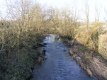
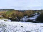
This brings us onto a tarmaced lane. Turn right and follow this lane as it curves around to the left, then straightens up and heads north, with the valley of the River Hamps to the right.
 We follow this track all the way into Grindon. About half way to the village the track passes across a dry valley, turning sharply right then left and passing a concrete pond. Just beyond this there is a split in the path - take the track that heads straight up the hillside, running along the left-hand side of the next field. We follow this through the next three fields, then move slightly to the right and follow a path that runs parallel to the track through a series of fields. Follow this path all the way into Grindon.
6: SK 087 543
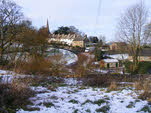
The path brings us onto a small lane at the edge of the village. Follow this short lane to reach the main village street. Turn right onto this street, then almost immediately left. This street drops down to cross a small dip - just after this turn right onto a signposted footpath that runs through a gap between the buildings.
 This brings us into a large field where we head for the far right corner. This brings us into a long ragged corner, with a stream running through the middle. At the far end of this field look for a path that heads into the trees of Ladyside Wood, using stone steps to cross a stone wall. Follow this path through the trees and all the way down to the Manifold.
We are now opposite the start of the path to Thor's Cave - if you wish to visit the cave cross the bridge and follow the path into the trees. After a short distance turn sharply right then follow this path up to the cave.
7: SK 098 551
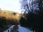
From our original path turn right onto the track (an old railway and now the route of the Manifold Way) that runs alongside the Manifold, with the river to our left. This track brings us to a small car park and then to a minor road. On the far side of the road two parallel tracks run down the valley - take the right-hand track.
8: SK 099 541
This track brings us to the junction of the Manifold and Hamps rivers. Follow the old railway as it curves around to the right to follow the line of the Hamps all the way back into Waterhouses (note the very welcome tea room at Lee House)
9: SK 091 500
This track brings us onto the main road through Waterhouses. Cross the road, then turn right and follow the road until a cycle path branches off to the left. Follow this track, which brings us back to the opposite end of our car park.
