
Introduction
![]() Blake Fell is one of the gems of the quiet western Lake District, especially when approached from Cogra Moss. For me this is a perfect miniature mountain landscape, with a lake and a forest with a dramatic fell looming over them, and an approach route that curls around a line of lesser summits before the final climb.
Blake Fell is one of the gems of the quiet western Lake District, especially when approached from Cogra Moss. For me this is a perfect miniature mountain landscape, with a lake and a forest with a dramatic fell looming over them, and an approach route that curls around a line of lesser summits before the final climb.
![]() Blake Fell is the highest of the Loweswater fells, and sits at the heart of a group of fairly gentle fells to the south of that lake. Blake is connected to a series of other fells by high ridges - the northern ridge runs to Burnbank Fell, the north-eastern to Carling Knott. In the south the fell slopes down towards the pass between Comb Gill and Highnook Beck. To the south of this pass is Gavel Fell, while to the north the high ground turns west to form High Pen.
Blake Fell is the highest of the Loweswater fells, and sits at the heart of a group of fairly gentle fells to the south of that lake. Blake is connected to a series of other fells by high ridges - the northern ridge runs to Burnbank Fell, the north-eastern to Carling Knott. In the south the fell slopes down towards the pass between Comb Gill and Highnook Beck. To the south of this pass is Gavel Fell, while to the north the high ground turns west to form High Pen.
Blake Fell thus has a west face and an east face. The east face is steep and grassy and is best seen from the High Nook valley, near Loweswater. The west face is steeper and rocky and includes some outcroppings of rock that give it a craggy look.
Statistics
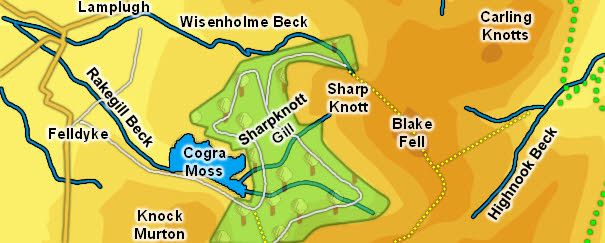
Grid Reference of Summit: NY 110 196
Height: 573m/ 1,878ft
Map
Routes of Ascent
The western slope is too steep to climb. The fell can be reached from High Pen in the south, a path that comes past Sharp Knott in the north, via High Nook in the east (this is a fairly steep path) or up the gentle slopes from Burnbank Fell in the north.
Walks
We have an ascent of Blake from Cogra Moss.
The Summit
![]() The summit of Blake is topped by a solid stone wind break. In most directions the ground drops away quite quickly (especially to the south-west), while a long grassy ridge runs away to the south-east. This is an airy summit, with great views into the heart of the Lake District and away to the Solway coast.
The summit of Blake is topped by a solid stone wind break. In most directions the ground drops away quite quickly (especially to the south-west), while a long grassy ridge runs away to the south-east. This is an airy summit, with great views into the heart of the Lake District and away to the Solway coast.
Streams and Tarns
Blake Fell can only really claim a fairly small area. It rises above a series of lower fells, each with their own separate identity. To the north is Burnbank Fell. Wisenholem Beck in the west and Holme Beck form the border between the two fells. In the east in Carling Knott, with Holme Beck to the north and Highnook Beck to the south.
![]() To the south is Gavel Fell, with Highnook Beck forming the eastern boundary. If you consider High Pen to be a separate fell then an unnamed beck marks the boundary with Blake Fell, running into Cogra Moss.
To the south is Gavel Fell, with Highnook Beck forming the eastern boundary. If you consider High Pen to be a separate fell then an unnamed beck marks the boundary with Blake Fell, running into Cogra Moss.
Sharpknott Gill rises in the dip between Blake and the subsidiary summit of Sharp Knott, running down into Cogra Moss.
Cogra Moss is Blake's only area of standing water. This pleasant little lake is artificial and covered the original moss, although some of the original swamp still survives at the eastern end of the lake.
Other Features
-