
Introduction
![]() Muncaster Fell is one of the best of the lower Lakeland fells, a lovely mix of heather and rocky outcrops sitting between the Esk and Mite Valleys, and offering stunning views of Eskdale and the high fells in one direct and the Cumbrian coast in the other. The fell itself is a delight, crossed by two long paths, one that runs along summit ridge and another more level track a little to the south.
Muncaster Fell is one of the best of the lower Lakeland fells, a lovely mix of heather and rocky outcrops sitting between the Esk and Mite Valleys, and offering stunning views of Eskdale and the high fells in one direct and the Cumbrian coast in the other. The fell itself is a delight, crossed by two long paths, one that runs along summit ridge and another more level track a little to the south.
The fell takes the form of a long ridge, with steep northern and southern slopes facing towards the river valleys, and a long undulating summit area, stretching from the highest point on the fell at Hooker Crag in the west to Ross's Camp (an old Victorian picnic table made out of large boulders and now slowly falling apart). The eastern ridge then drops down towards Silver Knott, another interesting rocky outcropping.
If time allows it is worth visiting Ravenglass, the only coastal village in the Lake District National Park, and Muncaster Castle is also worth a visit.
Statistics
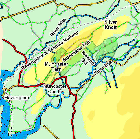
Grid Reference of Summit: SD 112 983
Height: 742ft/ 231m
Map
Routes of Ascent
![]() The main route of ascent of Muncaster Fell is along the long path that runs from the steep bend in the main road near Muncaster Castle all the way to Rabbit How south-west of Eskdale Green, where it joins a north-south path that runs from Irton Road Station to Muncaster Head farm.
The main route of ascent of Muncaster Fell is along the long path that runs from the steep bend in the main road near Muncaster Castle all the way to Rabbit How south-west of Eskdale Green, where it joins a north-south path that runs from Irton Road Station to Muncaster Head farm.
The northern side of the fell is both too steep and blocked by a railway line, while the southern slopes, which are less steep, does have one footpath that joins the main path near Muncaster Tarn.
Walks
We have a walk that visits Silver Knott at the eastern end of the fell, starting at Eskdale Green.
The summit is easy to reach from the west. Starting at the Muncaster Castle car park turn left onto the main road and follow it to a sudden sharp right-turn. At this point leave the road and follow Fell Lane as it climbs north-east up the fell. This brings us to the woods around Muncaster Tarn then continues on to the open fellside. At first the path runs alongside a field boundary, but at the end of this it splits - take the left-hand branch which climbs up Hooker Crag, clearly visible ahead - the summit is at the top of this short sharp climb.
The Summit
The summit of Muncaster Fell is Hooker Crag, one third of the way along the fell from the Muncaster Castle end. The highest point is a lovely mix of heather and rocky outcrops, with stunning views up Eskdale and out to sea. The western approach is steeper and longer, climbing up from the right of way that runs along the southern end of the summit ridge. The eastern slopes drop down towards Hooker Moss, with the long summit path seen winding its way east.
Streams and Tarns
Muncaster Fell sites between the River Mite (to the north) and the River Esk (to the south).
The north-eastern end of the fell is marked by Mere Beck, which rises to the north of Eskdale Green, flows west then turns south to run past Muncaster Fell and flow into the River Esk.
The south-western end of the fell is rather less clear - one could argue that it runs down to the sea, but I would feel that it ends around Muncaster Castle - to the north a wooded valley runs north from Branken Wall, while to the south a beck runs from the main road through the park around the castle, flows past the northern side of the main building then runs east into the Esk.
A number of becks rise on the sides of Muncaster Fell, but only Ridding Gill on the south side gets a name.
Muncaster Tarn, at the western end of the fell, is a lovely tree lined semi-artificial tarn (with dams at both ends), often coated with water lilies. The tarn is just off the public right of way, but is clearly visible and is worth a diversion.
Other Features
At the western end of the fell is Muncaster Castle, a fascinating house build around a medieval core and still owned by the Pennington family after 800 years. The castle is surrounded by a beautiful garden (especially good when the Rhododendrons are in bloom).
The Ravenglass & Eskdale Railway runs along the northern side of the fell (and embers from the trains have been known to trigger the odd fire. The track runs through trees for most of this part of the trip, but there are some views up the fell.