
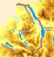
The River Derwent is one of the longest and most varied of the Lake District's rivers. It rises amidst the dramatic mountainous splendour of Borrowdale, flows through two very different lakes in Derwent Water and Bassenthwaite Lake, and then emerges onto the west Cumbrian plain and flows west to the sea at Workington.
![]() The Derwent is at its best in Borrowdale, and all of the valley's car parks are close to the river. The Derwent can be crossed on a foot bridge close to Derwent Water, by the road bridge at Grange, over New Bridge or by stepping stones at Rosthwaite, over the farm bridge at Longthwaite (public right of way), over a foot bridge just east of Seatoller, by the road bridge on the way to Seathwaite and by a footbridge at Seathwaite.
The Derwent is at its best in Borrowdale, and all of the valley's car parks are close to the river. The Derwent can be crossed on a foot bridge close to Derwent Water, by the road bridge at Grange, over New Bridge or by stepping stones at Rosthwaite, over the farm bridge at Longthwaite (public right of way), over a foot bridge just east of Seatoller, by the road bridge on the way to Seathwaite and by a footbridge at Seathwaite.
 The River Derwent is formed by the junction of Styhead Gill and Grains Gill at the southern tip of Borrowdale
The Derwent flows north through Borrowdale into Derwent Water. From the northern tip of Derwent Water it flows north into Bassenthwaite Lake, passing between Keswick and Portinscale. From Bassenthwaite the Derwent flows west to Cockermouth, where the Cocker joins it. The Derwent then continues on to the west, reaching the Irish Sea at Workington.
Sources
Styhead Gill
Grains Gill
Borrowdale
Hind Gill
Sourmilk Gill
Newhouse Gill
Black Sike
Hause Gill
Combe Gill
Tongue Gill
Frith Gill
Broadslack Gill
Ellers Beck
Comb Gill
Between Derwent Water and Bassenthwaite Lake
River Greta (west of Keswick)
Lair Beck
Wath Beck
Below Bassenthwaite Lake
Coal Beck
Blumer Beck
Singleton Gill
River Cocker (at Cockermouth)
Eller Beck
Broughton Beck
River Marron (close to Bridgefoot)
Harry Gill
Holdens Gill
Scale Beck
Go to Clickable Map of Rivers of the Lake District