
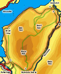
 This walk falls into three very different sections. We start with the climb up from Patterdale to Boredale Hause, a steady climb with ever-improving views of Patterdale and the Helvellyn range. The second stage is a full-length descent of Boredale, which starts as a wild glacial valley and ends in delightful country on the shores of Ullswater. The third stage is the best and takes us around the stunning path that runs above the southern shore of Ullswater, with glimpses of crags up above and the lake always present to the right.
You may wonder why we chose not to climb Place Fell itself - the answer was wind gusting up to 70mph which made it quite hard to keep our feet at Boredale Hause, and forced other people to abandon the final climb half way up!
Ascent: 1,800ft
Length: 8.35 miles
Map: Lakes North-East
Last Walked: April 2013
We start from the pay and display car park opposite the Patterdale Hotel - this is a walker's car park with a reasonable all day charge.
![]() On the far side of Side Farm turn right onto a track that runs along the base of Place Fell. Follow this track to a gate that takes us onto the side road at Rooking. Here turn left and climb up to join a higher footpath that runs along the fellside. Turn right onto this path.
On the far side of Side Farm turn right onto a track that runs along the base of Place Fell. Follow this track to a gate that takes us onto the side road at Rooking. Here turn left and climb up to join a higher footpath that runs along the fellside. Turn right onto this path.
The OS map shows this path splitting with two parallel paths climbing up to Boredale Hause. On the ground the junction isn't at all clear and the upper path is by far the more obvious. Follow this path as it climbs up towards Boredale Hause. Just before the top of the pass the upper path stops, and we cut across to the lower path.
![]() This brings us to the top of the pass. Boredale Hause is crossed by a large number of paths, and at first it isn't clear which one leads where. We need to reach the path that drops down into Boredale, so aim for the lowest point on the skyline. Ignore
This brings us to the top of the pass. Boredale Hause is crossed by a large number of paths, and at first it isn't clear which one leads where. We need to reach the path that drops down into Boredale, so aim for the lowest point on the skyline. Ignore ![]() the path that crosses Stonebarrow Gill heading for Angle Tarn, and the eventually obvious path that climbs up the southern slopes of Place Fell.
the path that crosses Stonebarrow Gill heading for Angle Tarn, and the eventually obvious path that climbs up the southern slopes of Place Fell.
The lower middle path soon becomes quite clear, and heads towards a 'V' shaped notch at the edge of the hause. A clear path heads along this notch, and looks to be heading for a ![]() bit of a precipice, but as you get closer to the apparent edge the rest of the path comes into sight. The first part of the decent takes us down a quite steep (but safe) path, but this soon levels out and becomes a clear track that runs down the upper reaches of Boredale. Look out for the large red deer herds on the fells to the right of the valley.
bit of a precipice, but as you get closer to the apparent edge the rest of the path comes into sight. The first part of the decent takes us down a quite steep (but safe) path, but this soon levels out and becomes a clear track that runs down the upper reaches of Boredale. Look out for the large red deer herds on the fells to the right of the valley.
We follow this track for quite a distance. At Boredale Head farm it turns into a minor road, running to the left of Boredale Beck. Follow the road as it crosses the beck then climbs gently (with a large pond that isn't show on the OS map on the left). Soon after this climb a right of way crosses the road.
![]() Turn left onto this path and follow it down to the beck. Cross the beck on a very attractive stone footbridge. The path then leads to the far-right corner of the next field, then cuts diagonally and to the right across another field, heading for a pair of stiles). Cross these styles, which brings us onto the open fell side. Turn right and follow a path that runs alongside the stone wall. This soon merges with a path coming down from the fell and becomes much clearer.
Turn left onto this path and follow it down to the beck. Cross the beck on a very attractive stone footbridge. The path then leads to the far-right corner of the next field, then cuts diagonally and to the right across another field, heading for a pair of stiles). Cross these styles, which brings us onto the open fell side. Turn right and follow a path that runs alongside the stone wall. This soon merges with a path coming down from the fell and becomes much clearer.
Turn left onto a major footpath that runs alongside this wall. This is the start of the delightful lake-side path. At first this path follows the wall, heading briefly away from it as it runs below Scalehow Force. Soon after this the wall disappears and the path runs above the southern shore of the lake, running through a fascinating area of woodland, with unexpected viewpoints.
![]()
![]()