
 This walk explores the eastern shores of Derwent Water, using the ferry to reach Lodore, and returning along a mix of footpaths, ledges and roadside paths. This walk is designed for the aftermath of very wet weather, which can often force the closure of most of the landing places for the Derwentwater Ferry.
Ascent: 500ft
Length: 3.5 miles
Map: The English Lakes - North Western Area (OS Explorer Map Active) (OS Explorer Map Active)
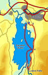
We start at Keswick, but then take the ferry to the southern landing place at Lodore.
![]() After this headland the lake closes up on the road. If water levels are low it is possible to walk along the lake shore here, but if the water is higher then the gap soon becomes too narrow. In either case stay on the lake shore to start with, at least as far as a landing stage opposite the road to Watendlath. If water levels are high then leave the lake shore at this landing stage, turn left onto the road and follow it north - there is soon a useable footpath by the side of the road.
After this headland the lake closes up on the road. If water levels are low it is possible to walk along the lake shore here, but if the water is higher then the gap soon becomes too narrow. In either case stay on the lake shore to start with, at least as far as a landing stage opposite the road to Watendlath. If water levels are high then leave the lake shore at this landing stage, turn left onto the road and follow it north - there is soon a useable footpath by the side of the road.
At the southern edge of Great Wood another permissive footpath leaves the road to the left, to run through the trees that line Calfclose Bay. There is now a choice of routes - the prettiest option is to follow the lake shore path, which apart from a couple of diversions follows the water around some attractive bays, reaching Friar's Crag and Keswick. The alternative is to take a path that branches off into the woods, eventually reaching a permissive footpath that runs to the left of the road.