
 This walk takes us around one of the most isolated of all of the Cumbrian lakes - Ennerdale Water - the only one of the lakes not to have a road running along its full length. After starting on Ennerdale's infamous forest road, most of this walk uses delightful lake-side paths. On a clear day this walk is dominated equally by the lake itself and by the bulk of Pillar, which dominates the upper valley.
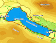
One note of caution - this walk does contain one minor obstacle at Anglers Crag, where the rocks come down to the lake-shore. Here we offer a route that climbs over Anglers Crag, taking advantage of this viewpoint, and accounts for most of the 750ft of ascent on the walk.
Ascent: 750ft
Length: 6.5 miles
Map: The English Lakes - North Western Area (OS Explorer Map Active)
Last Walked: 29 September 2008
We start from the Bowness Knott Car Park at the very end of the road into Ennerdale.
![]() The only obstacle on our walk is Anglers Crag, which juts out into the waters of the lake. There are two ways around this barrier. The most used is the lake-side footpath, which clambers up rather awkwardly over some of the protruding rocks - take this route if you don't mind a bit of scrambling but don't want to climb.
The only obstacle on our walk is Anglers Crag, which juts out into the waters of the lake. There are two ways around this barrier. The most used is the lake-side footpath, which clambers up rather awkwardly over some of the protruding rocks - take this route if you don't mind a bit of scrambling but don't want to climb.
![]() By far the best route takes us over the top of Anglers Crag, but this also involves a bit of scrambling. In theory the path to the top of Anglers Crag leaves the lakeside path just after we pass through the last wall before the crag, but the bottom part of that path has largely disappeared. Fortunately the slope to the left is shallow enough to make an entertaining little climb. Continue on past the wall for a few hundred feet, and then look for a suitable place to leave the path. Climb up diagonally to the left, aiming just above the saddle between Anglers Crag and Crag Fell - this should bring you onto the path, which becomes increasingly clear as one gets higher up the hill (and can be seen quite clearly from the top of the crag!). Once on this path follow it onto the saddle of land between the crag and the fell.
By far the best route takes us over the top of Anglers Crag, but this also involves a bit of scrambling. In theory the path to the top of Anglers Crag leaves the lakeside path just after we pass through the last wall before the crag, but the bottom part of that path has largely disappeared. Fortunately the slope to the left is shallow enough to make an entertaining little climb. Continue on past the wall for a few hundred feet, and then look for a suitable place to leave the path. Climb up diagonally to the left, aiming just above the saddle between Anglers Crag and Crag Fell - this should bring you onto the path, which becomes increasingly clear as one gets higher up the hill (and can be seen quite clearly from the top of the crag!). Once on this path follow it onto the saddle of land between the crag and the fell.
For most of this last section of the walk the lake is lined by fields, but as we approach Bowness Knot and the car park a patch of rough craggy ground comes into site. A maze of paths cross this patch of ground, while the lake shore path runs around its flanks, joining the forest road below the car park.
The most direct route back to the car park leaves the lakeside path as soon as it enters this rough ground. Turn left onto a path which soon joins a green lane, which itself leads back to the road just at the entrance to the car park.