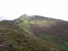
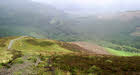
 This ascent of Grisedale Pike takes us up one ridge and down another, giving us two different views of this shapely peak, and presumably excellent views from the summit (although the weather closed in on me as I reached the top, so I can't entirely be sure!).
Ascent: 1,650ft
Length: 4 miles
Map: The English Lakes - North Western Area (OS Explorer Map Active)
Last Walked: Autumn 2011
We start at the Masmill Car Park
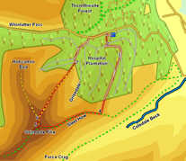
1: NY 214 244
An examination of the map shows that the forest tracks at Masmill don't connect with the tracks we need to use to reach Grisedale Pike, but fortunately there is a way through. Starting in the car park, head west towards the exit. At the point where the track curves around to the right to head to the road, a clear path (probably formed by forestry machines) climbs up the slope to the left. Follow this clear path, which brings us up to another forest track.
2: NY 213 242
Turn right onto this track and follow it to a nearby junction. Turn sharply left and back at this junction and follow the new track as it curves around to the right.
3: NY 214 241
This track eventually splits in two. Take the right-hand branch. Follow this track all the way to the edge of the forest (ignoring another track that merges from the right about half way through the
trees). At the edge of the forest the track ends, but a footpath continues on. Cross a stile to reach the open fellside. At this point there are two options - one path turns right and climbs up alongside the forest fence. The second heads straight across the fellside. Take this second path - the path by the forest fence is both overly steep and slippery in places).
4: NY 211 229
Our path soon joins up with one of the main routes up Grisedale Pike. Turn right onto this path and follow it as it climbs up onto the fell's eastern ridge. At the top of the ridge turn left and follow the path that runs along the ridge (named Sleet How at this point).
5: NY 199 226
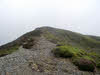
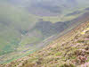
This path eventually reaches the north-eastern end of the summit, at the head of the valley of Grisedale Gill. Turn left to visit the highest point of the summit, and then return to this point. This time, instead of turning right onto Sleet How, we turn left, heading along the fell's northern ridge.
6: NY 198 227
After a short distance this ridge splits in two. We take the right-hand branch (the north-eastern ridge). A clear path runs alongside a stone wall. Follow this path and wall all the way down the ridge and to the edge of the forest.
7: NY 206 239
Follow the path as it enters the forest. We soon reach a forest track, close to a junction. Take the branch that crosses Sanderson Gill, reaching another junction just over the stream. Turn right here and follow this track as it heads to the Revelin Moss car park (ignore a side-branch heading off to the left). Leave the car park onto the right, turn right and follow the road back to Masmill.
