
 This is a spectacular walk, but really one for experienced fell walkers only, including as it does the steep climb up the front of High Stile from Burtness Comb. At no point did my route come close to sudden drops, but the climb from the comb to the summit is steep all the way, so be warned!
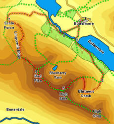
With that in mind this is one of the most impressive walks possible from Buttermere. Burtness Comb is a rocky wilderness, overlooked by dramatic crags, and there is a great feeling of achievement that comes from climbing High Stile by such an apparently difficult route.
Ascent: 2,600ft
Length: 6.5 miles
Map: The English Lakes - North Western Area (OS Explorer Map Active) (OS Explorer Map Active)
Last Walked: July 2010
We start on the bridge in Buttermere, next to the Bridge Hotel
Cross this first bridge then head up to the footbridge at the foot of Sourmill Gill. Cross this bridge and pass through the gate that leads into the woods. There are two main paths through these woods - the lakeshore path and our current path. Stay on our current path, ![]() which runs parallel to the lower path, but higher in the trees. Ignore any path that drops down to the lake, and the stone stairs that head off to the right (heading for Red Pike).
which runs parallel to the lower path, but higher in the trees. Ignore any path that drops down to the lake, and the stone stairs that head off to the right (heading for Red Pike).
![]() After about half a mile this path splits in two. Take the fainter right hand path, and follow it as it climbs out of the woods. Above the trees the path continues to run parallel to the woods. At the far end of Burtness Wood the path reaches a stone wall and turns right to follow the wall as it curves around into the entrance to Burtness Comb.
After about half a mile this path splits in two. Take the fainter right hand path, and follow it as it climbs out of the woods. Above the trees the path continues to run parallel to the woods. At the far end of Burtness Wood the path reaches a stone wall and turns right to follow the wall as it curves around into the entrance to Burtness Comb.
![]() Eventually the wall curves around to the left to head across the mouth of the Comb. At this point the path leaves the wall and continues to climb up towards the entrance to the comb, before splitting in two. The right hand branch is the public right of way up the front of High Stile, while the left hand path heads into the comb. Take the left hand path, which climbs up towards the rocky lip of Burtness Comb.
Eventually the wall curves around to the left to head across the mouth of the Comb. At this point the path leaves the wall and continues to climb up towards the entrance to the comb, before splitting in two. The right hand branch is the public right of way up the front of High Stile, while the left hand path heads into the comb. Take the left hand path, which climbs up towards the rocky lip of Burtness Comb.
![]() There are two options on from Red Pike. The quickest route is to follow the path that runs down the front of the fell, down the saddle, then along the path past Bleaberry Tarn, and down Old Burtness back to the bridge over Buttermere Dubs.
There are two options on from Red Pike. The quickest route is to follow the path that runs down the front of the fell, down the saddle, then along the path past Bleaberry Tarn, and down Old Burtness back to the bridge over Buttermere Dubs.
![]() The longer, and more interesting alternative, takes us along Lingcombe Edge, towards Scale Force. Turn left (from our original line of ascent), and follow the path that runs down the western slopes of Red Pike (with the crags of Lingcombe Edge just to the right). A short distance down the fell this path splits in two - take the right-hand branch, which continues along the Edge (the other path heads towards Starling Dodd).
The longer, and more interesting alternative, takes us along Lingcombe Edge, towards Scale Force. Turn left (from our original line of ascent), and follow the path that runs down the western slopes of Red Pike (with the crags of Lingcombe Edge just to the right). A short distance down the fell this path splits in two - take the right-hand branch, which continues along the Edge (the other path heads towards Starling Dodd).
There are several different paths from Lingcombe Edge to Scale Force. Here we are going to take the path that runs across Blea Crag. Follow the main path as it runs along the top of the edge. Where the path splits in two take the right-hand branch, which runs on towards the end of the ridge. This path then runs down towards the northern end of the ridge, before splitting again - this time take the main left-hand path, and follow it all the way down to Scale Beck.