
 This short walk takes us to the summit of Irton Pike, the last outcropping of high ground on the ridge that runs along the southern side of Wastwater. For very little effort it brings us to an excellent viewpoint for Wasdale, Eskdale and the coast.
Ascent: 400ft
Length: 1.5 miles
Map: The English Lakes - South Western Area (OS Explorer Map Active)
Last Walked: 5 December 2009
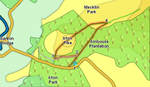
We start from the small car park built into a quarry on the road between Santon Bridge and Eskdale Bridge. If coming from Santon Bridge the car park is on the left, just after the road begins to drop down gently after the climb out of the village. If coming from Eskdale Bridge the car park is on the right, just past a sharp left-hand bend about a mile and a half from the centre of the village.
![]() The only difficult moment on the walk is finding the start of the path that runs up the front of the pike. When the slopes of the Pike were covered in trees it was no doubt easier to spot, but now the first few steps are rather indistinct. Look for a narrow path that starts by a silver birch and a distinctive tree-stump, with a series of horizontal cuts. A large gate on the road should be visible to the left.
The only difficult moment on the walk is finding the start of the path that runs up the front of the pike. When the slopes of the Pike were covered in trees it was no doubt easier to spot, but now the first few steps are rather indistinct. Look for a narrow path that starts by a silver birch and a distinctive tree-stump, with a series of horizontal cuts. A large gate on the road should be visible to the left.
The path becomes much clearer as we climb, and becomes very clear as we approach the top of Irton Pike. It then continues over across the summit and through the trees on the ridge that links Irton Pike to Whin Rigg.
![]()
![]()