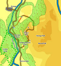
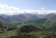
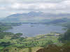
 This short but steep walk takes us to the summit of King's How, a fantastic viewpoint for Derwent Water and for Borrowdale. The summit is named after King Edward VII, who died in 1910, the same year in which the National Trust purchased the fell.
Ascent: 1,100ft
Length: 2.3 miles
Map:  Lakes North West
Last Walked: June 2012
We start from the National Trust's Bowder Stone car park.
1: NY 253 168
Head out of the car park towards the road. Just before the road turn left onto a footpath heading towards the Bowder Stone. Very early on the path appears to branch in two, with the left-hand branch heading along a cutting towards a quarry. Ignore this path and take the right-hand branch, which climbs up the slope to the side of the cutting, then runs through woods, passing the Bowder Stone before eventually dropping down to the road.
2: NY 254 160
Head south along the road for around 700ft, then turn left onto a signposted footpath that climbs up a gap of clear ground between areas of woodland. The path starts on the right of the open ground, then curves around to the left as it climbs, eventually reaching a good viewpoint above Andersonband Crag (probably). The path then continues to climb up quite steeply through the trees before emerging onto the open fellside.
3: NY 257 162
When the path emerges onto the open ground follow it as it runs alongside a stone wall for a short distance, then turns left and climbs up to the summit of King's How.
4: NY 258 166
Follow the path that heads north in the direction of Derwent Water from the summit. This makes its way safely down a series of rocky ledges before eventually reaching the edge of the trees.
5: NY 258 158
 At the edge of the trees ignore a side path that heads off to the left and follow the main path as it runs right, first through some trees, then along the northern edge of Long Moss, a flat swampy area between the summit crags of King's How and the next high ground.
After passing the moss the path turns to the left and begins to lose altitude, gently at first and then very rapidly down quite a long run of stone steps set in a wooded valley (much better to go down than climb up!).
At the base of the steps the path tends to curve towards the left, climbing up a shallow slope towards a stone wall. The path then passes over the top of a gentle ridge and begins to drop down again,
6: NY 255 172
A number of paths cross this area of fairly open ground. The best way back to the car park takes the left-hand branch at the main junctions, keeping the crags of King's How to the left and stays on fairly level ground before eventually reaching the far end of the car park.
