
 Although Loughrigg is really one of the minor fells, only just 1,000ft high, it's isolated position overlooking Grasmere and Rydal Water means that there are really impressive views in every direction, north towards Dunmail Raise, west towards the Langdale Pikes, south towards Windermere and east towards Ill Bell.
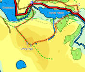
This particular walk leaves the main footpaths at the top of Loughrigg. A small unnamed stream crosses the summit plateau, heading east-north east from a small tarn close to the summit into a small valley in the north east of the fell. Our route follows roughly the same route as this small stream, following a series of reasonably obvious paths.
Ascent: 1,250 ft/ 390m
Length: 4 miles/ 7km
Map: Explorer 07 - English Lakes South East
Last Walked: 9 October 2007
We start from the NT car park at White Moss Common, just to the west of Rydal Water.
![]() Cross this bridge. Three paths lead away from the bridge, two following the river upstream and down, and a third that leads away from the river into the trees. Follow this third path.
Cross this bridge. Three paths lead away from the bridge, two following the river upstream and down, and a third that leads away from the river into the trees. Follow this third path.
![]() At the edge of the woods we reach a path running east-to-west across the hillside. Turn right onto this path, and follow it to the west, along Loughrigg Terrace. This part of the walk offers great views across Grasmere.
At the edge of the woods we reach a path running east-to-west across the hillside. Turn right onto this path, and follow it to the west, along Loughrigg Terrace. This part of the walk offers great views across Grasmere.
The main path continues on past the summit, first dropping down off the actual summit, and then dropping down another steep slope into a small valley.
![]() At this point a maze of paths criss-cross the summit. Our aim is to head north east across the summit (east north east if you have a compass with you), using the valley created by a small and apparently unnamed back to get back to the lake side. Here we describe the route we used to achieve this, but if you miss one of these paths, remember that our target is to head downhill, north east, safely.
At this point a maze of paths criss-cross the summit. Our aim is to head north east across the summit (east north east if you have a compass with you), using the valley created by a small and apparently unnamed back to get back to the lake side. Here we describe the route we used to achieve this, but if you miss one of these paths, remember that our target is to head downhill, north east, safely.
Just over 400 feet past the summit cairn, at the bottom of that steep slope, a smaller path leaves the main path to the left, heading towards a small tarn. Turn onto this path.
![]() Follow this path as it passes by the left hand side of that tarn. Just beyond the tarn, we reach a crossroads in the paths. Head straight across and follow the path, as it heads down another steep slope onto a swampy plateau (labeled Scartufts on the OS map).
Follow this path as it passes by the left hand side of that tarn. Just beyond the tarn, we reach a crossroads in the paths. Head straight across and follow the path, as it heads down another steep slope onto a swampy plateau (labeled Scartufts on the OS map).
A reasonably clear path heads across the swampy plateau heading roughly to the north east. Follow this path to the opposite side of the plateau. At this point a stream leaves the plateau, with a much clearer path roughly following the line of this stream. Follow this path.
We remain with this path for the next quarter of a mile, as it follows this small stream (sometimes deviating a little to the right to avoid waterfalls or crags). The path remains clear all the way.
After that quarter of a mile, our path (and the small stream) reaches another stream, running down a distinct valley towards Rydal Water. At this point we have a choice of paths - one continues on in the same direction as our original path, climbing back up out of the valley, while the other turns left and follows the stream down towards the lake. On our last walk, we turned left onto this path, which turned out to be muddly, unclear, slippy and generally tricky, so ignore it, and follow the straight path as it climbs up away from this stream. After a short distance you will reach a crossroads in the path. Turn left and follow the clear path that heads down hill towards Rydal Water.
After a short distance you will reach a group of impressive trees (where you will meet our muddy path). In the middle of these trees we find a major tourist footpath that runs west-to-east above the lake. Turn right onto this path.