 This delightful walk is one of the shorter lake circuits in the area, visiting one of the quiestest of all of the lakes - a rare gem on the very edge of one of the busiest parts of the district.
Ascent: 600 feet
Length: 4.4 miles (including Holme Force)
Map: The English Lakes - North Western Area (OS Explorer Map Active)
Last Walked: 16 March 2010
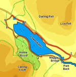
We start from the layby at the northern end of the lane (not the one with the phone box).
1: NY 121 223
A rough track leaves the eastern end of the car park (with the lake to the right). Follow this track until it rejoins the road, then follow the road. After a short distance another footpath drops down to the right and follows the lake shore, with the road just above to the left. Follow this path until it too runs out, then return to the road and follow it along the rest of the lake, and for just under half a mile after the end of the lake.
2: NY 137 211
After passing the end of the lake the road begins to climb, eventually reaching its highest point at the point where a minor road leaves to the right. Turn onto this road, and follow it down to the National Trust car park at Maggie's Bridge.
3: NY 134 210
Two farm tracks head away from this car park. Take the right-hand track, which begins right at the car park, and follow it across open fields towards Watergate Farm.
4: NY 126 211
At Watergate Farm follow the track as it curves around to the right and enters Holme Wood. Follow the main track as far as the National Trust bothy, a small stone building that can be hired as basic accomodation. Here leave the main track and follow a footpath that stays closer to the lake shore. Eventually this path rejoins the main track - turn right here and continue to the end of the woods.
5: NY 115 221
After leaving Holme Wood the track continues across some open fields (closely resembling park land), before reaching Hudson Place. Follow the track as it turns right to pass by this farm, ignore the right of way that leaves to the left just after the buildings, and continue along the track as it runs downhill towards the valley bottom.
6: NY 115 224
After running straight for some distance the track turns sharply right. After a shorter distance it turns back to the left. At this point leave the track and follow the footpath that continues on straight across the valley (be aware that this area can be quite muddy, despite efforts to raise the path above the mud). Follow this path all the way to the road, then turn right and follow the road back to our starting point.
