
 The Corridor Route is my favourite way to climb Scafell Pike. Starting at Sty Head this path cuts its way across the northern slopes of the Scafell massif, linking together a series of grassy shelves hidden amongst some stupendous rocky scenery. The path passes above the dramatic upper reaches of Piers Gill and Greta Gill, and below the often overlooked cliffs of Broad Crag. Not least amongst the surprise is Round How, which at just under 2,400 feet would be quite a major fell in its own right, at least if it didn't sit directly below the crags of Great End and Broad Crag!
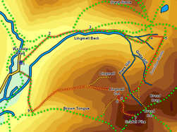
We return down the front of Lingmell, a route that avoids the tourist path on Brown Tongue, and that keeps us above 2,000ft for all but the last one and half miles of the route.
Ascent: 3,050ft
Length: 7 miles
Map: The English Lakes - South Western Area (OS Explorer Map Active)
Last Walked: 12 April 2010
We start from the village green car park in Wasdale Head.
![]() At this point the Valley Path leaves the main tourist route, and continues to follow Lingmell Beck up the bottom of the valley. Follow this path for the next two-thirds of a mile, until it reaches the point where Piers Gill flows into Lingmell Beck. We now need to cross Lingmell Beck to reach the tongue of land between the two becks. After dry weather this is very straightforward, but after heavy rain it can take some time to find a suitable crossing point.
At this point the Valley Path leaves the main tourist route, and continues to follow Lingmell Beck up the bottom of the valley. Follow this path for the next two-thirds of a mile, until it reaches the point where Piers Gill flows into Lingmell Beck. We now need to cross Lingmell Beck to reach the tongue of land between the two becks. After dry weather this is very straightforward, but after heavy rain it can take some time to find a suitable crossing point.
On the far side of Lingmell Beck a clear path follows an easy zig-zag route up an increasingly steep slope, climbing up towards a waterfall that sits very clearly on the skyline.
![]() Keep climbing until you reach a very obvious well maintained footpath, first seen as it climbs up towards the Gill from the left. This is the Corridor Route.
Keep climbing until you reach a very obvious well maintained footpath, first seen as it climbs up towards the Gill from the left. This is the Corridor Route.
![]() Turn right onto this path, and follow it as it climbs diagonally across the hill side, heading almost due south at first. This path is very clear almost all of the way to Lingmell Col, and is generally an easy path, with only one difficult moment as it cuts across the head of one of the dramatic ravines that cut into the slope.
Turn right onto this path, and follow it as it climbs diagonally across the hill side, heading almost due south at first. This path is very clear almost all of the way to Lingmell Col, and is generally an easy path, with only one difficult moment as it cuts across the head of one of the dramatic ravines that cut into the slope.
![]()
![]() For most of its length the Corridor Route is a single path, with no junctions. Only towards its western end do things get a little more complex, for there is a choice of two routes onto Scafell Pike - via Broad Col or via the top of the tourist route up Brown Tongue. Here we will be using the second of those routes (partly because it avoids a nasty steep climb near the top of the Broad Col route, but mainly because more of the view remains hidden on this route, making the final arrival at the summit even more satisfying!)
For most of its length the Corridor Route is a single path, with no junctions. Only towards its western end do things get a little more complex, for there is a choice of two routes onto Scafell Pike - via Broad Col or via the top of the tourist route up Brown Tongue. Here we will be using the second of those routes (partly because it avoids a nasty steep climb near the top of the Broad Col route, but mainly because more of the view remains hidden on this route, making the final arrival at the summit even more satisfying!)
![]()
![]() Soon after passing the top of Greta Gill we reach the first junction. One path branches off to the left to climb up to Broad Col, while our route continues straight on. A short distance further the Piers Gill path joins from the right. Our path splits in two where it meets Piers Gill - once again the left-hand branch goes up to Broad Col, while we want the right-hand path. This path climbs up from Piers Gill, and then splits again. The right-hand branch heads towards a path that runs alongside a stone wall, but this time we want the left-hand path, which climbs up towards the ridge above Lingmell Col.
Soon after passing the top of Greta Gill we reach the first junction. One path branches off to the left to climb up to Broad Col, while our route continues straight on. A short distance further the Piers Gill path joins from the right. Our path splits in two where it meets Piers Gill - once again the left-hand branch goes up to Broad Col, while we want the right-hand path. This path climbs up from Piers Gill, and then splits again. The right-hand branch heads towards a path that runs alongside a stone wall, but this time we want the left-hand path, which climbs up towards the ridge above Lingmell Col.
This path starts to become a little unclear once the line of the tourist path comes into sight. Head across and up the rocky slope until you reach the very clear Brown Tongue path, turn left and follow it all the way to the distinctive round flat summit cairn on Scafell Pike.