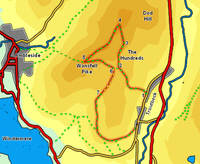
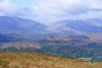
 This walk takes us to a typical Lakeland viewpoint, but through countryside that often feels like it has been transplanted from the Dales. The first part of the walk is dominated by the view east towards Ill Bell and the long steep-sided ridge that runs up to High Street, but the view from the top of the Pike looks straight into the heart of the district.
Ascent: 1,250ft
Length: 5 miles
Map: Map: The English Lakes - South Eastern Area (OS Explorer Map Active)
Last Walked:
There is a limited amount of roadside parking in Troutbeck, so if you are driving you will have to start from whereever you can. For the purposes of this walk we will start from the post office at Low Fold.
1: NY 409 033
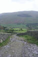
Head north along the main street through Troutbeck for just under half a mile. For most of the time the buildings are concentrated on the right of the road, with two exceptions - the first is a sizable cluster of buildings on the left around the post office, and the second is a smaller group of buildings close to our footpath. Once you reach this second cluster of buidlings to the left of the road look out for a public foot path that runs up a narrow rocky lane (Nanny Lane). Turn left onto this lane. The first short stretch runs due west up the hill. It then turns right, left and right again before finally turning left to begin a longer straight climb west up the hill.
2: NY 402 040
After the initial straight climb our lane swings right and then left before reaching another right-hand turn, where a public footpath is signposted leaving to the left. Ignore this very clear path and continue right along the track, which is now much less worn (and a bit muddy).
3: NY 403 045
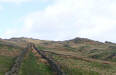
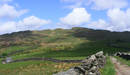
Follow this lane for as long as it runs between two stone walls. Just before the track emerges into a field a footpath leaves to the left, using a ladder stile to cross the wall. On the far side of this stile a clear path turns right, and runs alongside the wall, while a
somewhat fainter path appears to head left, climbing up around a grassy mound in front of the stile. Take the left hand path, which very quickly curves around to the right, and heads diagonally across this field, heading almost due north towards the highest point at the northern end of Wansfell. Follow this path all the way to this northern summit.
4: NY 403 051
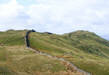
A clear path runs south/ south-west along the summit ridge, heading for
Wansfell Pike. Follow this path as it runs along the undulating ridge.
5: NY 394 041
At the summit we reach a t-junction. The left hand turn is our eventual route onwards and back to Troutbeck, while the right hand turn crosses a fence to reach the rocky summit of the Pike. Take this right-hand path for the moment, which brings us to a surprise view down into Ambleside, and a fine viewpoint into the Langdales. Afterwards head back across the fence and follow the other path, as it heads down the eastern side of Wansfell Pike.
6: NY 401 040
After about half a mile this path crosses its first stone wall. Here we have a choice of routes. For a quick return to Troutbeck continue straight along our path, which brings us back to the lane at step two, then turn right to head back into the village. To follow the full route, turn right onto the footpath that runs just behind the stone wall, heading south towards Windermere. Follow this path across the next two fields.
7: NY 399 034
This path brings us onto a lane that runs across the second field. Turn left onto this lane, the follow it as it curves around to the right to leave the field. After that follow the lane as it curves left around the hillside, before eventually it drops down into Troutbeck village at Low Fold.
