
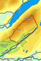
 This walk visits two very contrasting areas - first the quiet valley of Miterdale, where you will probably only meet one or two people (if that), then the path that runs above the Wasdale Screes, a much busier route, but normally climbed from Wasdale Head.
This walk involves one pathless section where we climb up the southern slopes of Illgill Head - a steep walk rather than a scramble. The drop down from the ridge back into Miterdale is steeper, but does follow a clear path.
Ascent: 2,000ft
Length: 7.5 miles
Map: The English Lakes - South Western Area (OS Explorer Map Active)
Last Walked: September 2010
We start from the small Forestry Commission parking space close to Porterthwaite. This can be reached along the narrow lane that runs past Eskdale Green School (to the west of the main part of the village).
![]() This path eventually brings us into a remarkable rocky amphitheatre, ringed with waterfalls. There are two ways out of this area - the most direct climbs up a grassy slope to the right of the main waterfalls, emerging at the top of the crags. The other involves retracing our steps a few paces to the point where a path branches off to climb out of the valley. This path brings us to the right-hand side of the amphitheatre, from where we swing left to reach the same point.
This path eventually brings us into a remarkable rocky amphitheatre, ringed with waterfalls. There are two ways out of this area - the most direct climbs up a grassy slope to the right of the main waterfalls, emerging at the top of the crags. The other involves retracing our steps a few paces to the point where a path branches off to climb out of the valley. This path brings us to the right-hand side of the amphitheatre, from where we swing left to reach the same point.
![]() We are now at the head of Miterdale. The low slopes of Boat How are to our right, Burnmoor Tarn is ahead of us, with Scafell beyond, and the slopes of Illgill Head are to our left. This is where we leave the path, turn left and make our own way up the mostly grassy slopes of Illgill Head - aim for the skyline, avoiding the steeper parts of the slope.
We are now at the head of Miterdale. The low slopes of Boat How are to our right, Burnmoor Tarn is ahead of us, with Scafell beyond, and the slopes of Illgill Head are to our left. This is where we leave the path, turn left and make our own way up the mostly grassy slopes of Illgill Head - aim for the skyline, avoiding the steeper parts of the slope.
Eventually this climb will bring us to the path that runs along the top of the ridge. Turn left onto this path and follow it to the summit of Illgill Head. We then continue along the ridge to Whin Rigg. There are two paths along this grassy ridge - one that follows the centre of the ridge and a second that runs along the top of the Screes. This is the more interesting path, offering dramatic glimpses down the crags towards the screes and Wast Water. The two paths eventually merge to reach the top of Whin Rigg, and then continue on down the grassy southern end of the ridge. Follow this path until it reaches a stone wall.
![]()
![]()
![]()
![]()