
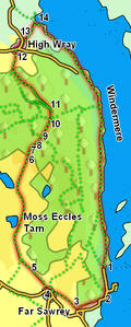
 This walk explores part of the western shore of Windermere, starting with a walk through the woods above the lake before returning to our starting point along the lake shore. On the way we pass a series of delightful small tarns, beginning with Moss Eccles Tarn, as well as passing through the small village of Far Sawrey.
Ascent: 992ft/ 300m
Length: 8 miles/ 13km
Map: Explorer 07 English Lakes South Eastern Area
Last Walked: 12 October 2007
This walk starts from the lakeside parking north of the ferry across Windermere. It is also possible to start from the car park close to the ferry, or even to start in Bowness and use the ferry to reach our starting point.
The lakeside road soon joins the road to the ferry. We will follow the route of this road for some way, but we only use the road itself for a short distance. Two paths lead off into the trees to the right. Ignore the first one, which leads up quite steeply inside the trees, but take the second path, which heads in the same direction as the road, but runs through the trees.
This path passes through a small car park, continuing past the car park on the same side of the road. It then crosses over the road and follows the left side of the road as it climbs up away from the lake shore. We follow this permissive path alongside the road until it emerges back onto the road at a small junction.
At this small junction we follow the main road, ignoring the minor road that turns off to the left. After a short distance the main road itself begins to curve to the left. At the corner a footpath leaves the road to the right, heading uphill, running to the right of a small piece of woodland. Follow this path.
This path runs straight over a shoulder of the hill (which the road swings around), passing between a series of private houses. At the top of the climb the path passes in front of Sawrey Knotts, before continues on down into Far Sawrey, rejoining the road just before the pub.
We follow this track for just over 800 feet as it curves around the hill, before we reach a path that leaves the track to the right, heading in roughly the same direction. Turn right onto this path and follow it as it runs back into the trees. We follow this path for just over half a mile through the trees, ignoring any track that leaves to the right.
At the edge of the woods we pass a National Trust base camp, used for conservation volunteers. From the base camp follow the road that leads north, heading towards High Wray